About Sunriver
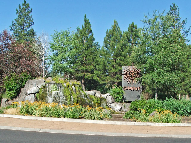
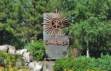
Sunriver…even the name seems relaxing. Located in central Oregon on the "dry side" of the Cascade Range, it has called to those seeking recreation and relaxation for over three decades and continues to receive awards and accolades from American Way Magazine to USA Today. At an elevation of 4,200ft, Sunriver sits on the edge of Oregon's high desert plateau and is bordered by the Deschutes National Forest to the north and the Deschutes river to the west. Whether you're new to this area or a regular visitor, chances are you don't know the history behind this unique resort community. So sit back and enjoy the following brief history of Sunriver and the surrounding area.
Early History
The early history of Sunriver begins with the westward expansion, in general, and the United States Army, in particular. The area now called Central Oregon was not known, outside of a few hunters and trappers, until 1843 when a U.S. Army survey expedition mapped the country from what is now Bend to the Klamath area. Nearly ten years later in 1852, the area was again examined when a group scouted it looking for a favorable route to use in building a road from Eugene City to Fort Boise.
In 1855, the U.S. Army began conducting the Pacific Railroad Survey, searching for a rail route from the Sacramento Valley to the Columbia River. The Williamson Survey Party, following an ancient Indian trail from the south, camped at an expansive meadow along the Riviera Des Chutes--a name given it by French trappers meaning, literally, "river of the rapids". Under the command of a young engineer, Second Lieutenant Henry Larcom Abbot, this survey party "discovered" the area upon which Sunriver now sits (roughly four years before the State of Oregon would be established).
Just over a decade later in 1867, Fort Klamath in southern Oregon found itself in need of supplies, especially meat. To fill this need, the U.S. Army cleared a trail through central Oregon from Fort Dalles to Fort Klamath, bringing the needed cattle with them and opening a north-south route through the area.
The Early Settlers
This new route, along with an east-west route over the Cascade mountains, turned the area into a crossroads. The trail soon became a full-fledged wagon road connecting Fort Dalles and Fort Klamath. Cattlemen, who valued the lush meadows and abundant grass found along the Deschutes river, quickly took advantage of this newly opened area. From the late 1870s to the early 1890s, a number of large ranches were established and several communities sprang up with schools, post offices, etc. F.A. Shonquest owned one of the best-known of these ranches which covered an area that included the former campsite of Lieutenant Abbot and his men.
In 1900, Alexander Drake founded the community of Farewell Bend on the site of the former Farewell Bend Ranch. In 1905, the "Farewell" was dropped and the community was formally incorporated into the city of Bend in what was then Crook County. Three years later the Deschutes National Forest was established and by 1912 Bend was being served by a new railroad line to the Columbia River. In 1916, Crook County was divided and the portion containing Bend (and the Shonquest ranch) became Deschutes County.
Area Gains Notariety
Roads and trains brought growth to the area and by the early 1920s, the population of Bend had exceeded 5,000 and the surrounding area was gaining notariety for its natural wonders. Fast becoming a favorite of hunters, anglers, and cavers, the upper Deschutes region received national attention when the famous Saturday Evening Post writer Irving S. Cobb visited the area shortly after World War I. A few years later, it would gain the spotlight again when visited by (then former) president Herbert Hoover.
During this period, a number of small roads southwest of Bend were connected creating a 100-mile loop from Bend, west into the mountains, and then back. Because of its length, the new road was called Century Drive. Its northern leg is still the primary method of getting from Bend to the mountains and, until the creation of the Spring River Road short-cut, its southern leg was a primary route from Sunriver to Mt. Bachelor. Its creation ultimately led to the development of a very different kind of recreation for the area. In the early 1940s the Hoodoo ski area opened and skiing as well as other snow-related activities took hold.
The Army Returns
Lieutenant Henry Abbot's career didn't end with the railroad survey party. He went on to serve with distinction in the Civil War, achieved the rank of brigadier-general, and was named by president Theodore Roosevelt to the Board of Consulting Engineers responsible for preparing the Panama Canal construction plans.
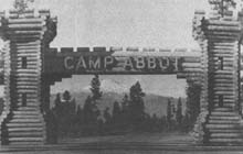
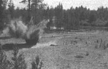
During World War II, the Army Corps of Engineers needed a center for training replacement engineers in building bridges and roads, constructing canals, and performing demolition duties. The site chosen for this training camp spanned nearly 9,700 acres including the old Shonquest ranch and the original survey party camp site. Built in just over five months at a cost of roughly four million dollars (in 1943 dollars), this new center was named Camp Abbot for that young Lieutenant who had not only "discovered" the area, but had served his country so well.
But the war didn't last and neither did the camp. Just over a year later in 1944, and after having trained 90,000 personnel, the camp was closed and then decommissioned. Of the many buildings, bridges, and other areas developed during its short life, only two remain today. The Great Hall that stands just southeast of the Lodge was originally built as the Officers' Club and the small creek, affectionately referred to as "Sun River", was created by the Corps for training purposes. No longer used, the area then set idle for over two decades.
The Birth Of Sunriver
In 1954, state highway 97 was completed in its current location and four years later, the Mt. Bachelor ski area opened. Both served to make Central Oregon a prime vacation and recreation area. At the same time, the local economy began the transition from timber to tourism--a trend that continues today.
In the mid-1960's, Don McCallum (a real-estate lawyer and the president of a sizable title company) believed that the time was right for a resort development in Central Oregon. He took his idea to John Gray, the head of Omark Industries who had developed the Salishan resort on the Oregon Coast in 1965 (Gray would later develop the Skamania Lodge in Stevenson, Washington which opened in 1995).
Both men wanted a development that was no ordinary resort community, but a unique ecological experiment…a "city" that would show humans could live in harmony with nature. With that in mind, Gray remembered a chance encounter he'd had while walking along the deserted beach at Salishan. There, he'd met Jim Anderson, a self-taught naturalist and educator who was teaching classes and leading field trips for OMSI (the Oregon Museum of Science and Industry). Coincidentally, Gray's children had become familiar with Anderson while spending time at OMSI.
Gray convinced Anderson to help plan the new resort and recruited Robert Royston, an architect and planner, to complete the small team that pledged to do more than pay lip service to protecting the environment. With the key people in place, Gray and McCallum began work on their vision, choosing an area just south of Bend, consolidating over one-hundred individual parcels of land (including the old Camp Abbot), and selecting Sunriver as its new name.
In 1968, Sunriver Properties Inc. was founded with McCallum as president. The announcement was greeted enthusiastically and development of Phase I began quickly. Because planners wanted to retain as much of the natural, unspoiled beauty as possible, strict controls on development were instituted (from building location and design to paint color and landscape maintenance). Critics doubted the whole thing would survive more than two years.
But survive it did! Just one year later, in April 1969, the Lodge, several tennis courts, the lodge condos, and the (south) pool were complete. The following year would see completion of the airport, (south) golf course, bike paths, and stables. By 1971 the population stood at 109 and Sunriver was booming.
Tough Times
Still, it wasn't all smooth sailing. The deep recession of 1973-74 hurt recreation industries and projects all across the nation. Sunriver was no exception and it wasn't too long before it began to sink into red ink. To regain financial stability, the developers entered into negotiations to sell nearly 2,200 acres at the north end of the property to the U.S. Forest Service for $2.8 million. This promised cash infusion slowed the bleeding and helped keep development on track.
It also created one of the greatest Sunriver mysteries of all time. A quick look at a map shows traffic circles scattered throughout Sunriver and seemingly numbered from one to eleven. But sooner or later everyone notices that circle #8 is strangely missing. So what happened to it? In the original design, the roads and areas it would have served were located within the 2,200 acres that were to be sold to the Forest Service. As a result, circle #8 was no longer necessary and, therefore, never built.
Recent History
By the middle of 1976, the economy was pulling out of its slump, Sunriver was celebrating its eighth birthday, and plans for the development of Phase II were in place. While Phase I focused on the south end of the Sunriver property, Phase II would focus on the undeveloped north end. Scaled back to accomodate the property sale (which was completed in 1978) this area was marketed primarily to potential buyers in California.
In spite of pressure to adopt more common development methods, Sunriver's founders remained true to the environmental ideals they had begun formulating over a decade before. This led to Sunriver becoming the first private community in Oregon awarded the "Tree City, USA" designation and an honorable mention by Charles Kuralt, in the CBS series "On The Road", who said:
"All real estate developers these days talk about ecology, by which they mean not cutting down quite all the trees. To find a developer who really does believe that what's good for the deer and the owls and the grass and the river is also good for people is an overwhelming surprise, but that's what we found in Sunriver, Oregon."
By the mid-1980's, development of the "north end" was well on its way with the addition of the Woodlands golf course, several new tennis courts, the Sunriver Marketplace (aka "North Store"), a second entrance at Cottonwood Road, and the north pool (completed in 1984). With roughly 800 condos and 1,500 homes by 1986, Sunriver was quickly growing into a small town. That year, the Sunriver Owners Association was created to fill the role, and provide the services, of a city government. Bend, too, was growing and by 1990 had a population of just under 20,500.
By 2000, Deschutes County was growing at a rate faster than any other county in Oregon and Bend's population had skyrocketed to over 52,000. Hwy 97 was no longer a rural highway passing through a small town. It was now a clogged thoroughfare in an increasingly crowded city. As a result, the Oregon Department of Transportation began contruction of the "Bend Parkway" which it completed in 2001. This re-routing of Hwy 97 reduced the time to get through Bend by 30 to 50 minutes and made getting to Sunriver from the north a much less frustrating experience.
In May 2012, the Sunriver Homeowners Aquatic & Recreation Center (SHARC) opened its doors. The $18 million aquatic and recreation facility replaced the aging "South Pool" (located near the Sunriver Resort Lodge) that was over forty years old and did not have the capacity to meet the number of users. In its first five years, the SHARC saw over 1.4 million visitors. The property where the old pool was located was exchanged with Sunriver Resort and a year later the open area known as Besson Commons (named after Col. Frank Besson, the commanding officer of Camp Abbot) was completed.
Today, central Oregon remains a vacation destination for thousands from all across the western states. Yet Sunriver, covering over 3,300 acres with some 900 condos, 3,000 homes, and a year-round resident population of around 1,500 remains the idyllic community envisioned over three decades ago. Though Camp Abbot no longer exists, you'll find reminders throughout Sunriver. Abbot Drive, Abbot Condos, and the intriguing (and often confusing) Abbot Circles all pay homage to the man, and the camp.