Volcano Activities
Part of the Pacific "Ring Of Fire", Central Oregon is home to a number of volcanic features that comprise the Newberry Volcanic Monument within the Deschutes National Forest. The Monument includes over 54,000 acres with lakes, lava flows, cinder cones, vents, and spectacular geologic features. One of the latter is Paulina Peak, a volcano approximately 1,200 acres in size (roughly the size of the state of Rhode Island) that towers 7,985 feet above the surrounding area.
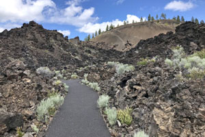 Hike—Lava Lands (Self-guided)
U.S. Forest Service
58201 U.S. Hwy 97, Bend
541-593-2421
From the Lava Lands Visitor Center, walk the mile-long Trail of the Molten Land that runs through the basalt lava flow to the base of Lava Butte or the Whispering Pines Trail. Interpretive signs tell the story of the eruption of Lava Butte and substantial portions of the trails are fully accessible to those with mobility challenges. For something more challenging, hike the paved road that climbs 500 feet to the top of Lava Butte.
"Lava Lands offers nature walks, interpretive programs, visitor information, displays on geology, volcanology, and the culture of Central Oregon." —U.S. Forest Service
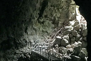 Hike—Lava River Cave (Self-guided)
U.S. Forest Service
Cottonwood Dr., Sunriver
541-593-2421
Offers an approximately 1.5 hour self-guided exploration of the mile-long Lava River Cave. Initial access is by a long stairway descending to a combination of flat boardwalks, uneven surfaces, and additional stairways. Visitors should wear closed-toe shoes and warm clothing (average cave temperature is 42 degrees. Remember to bring or rent two light sources. Pets are not allowed in the cave.
"Lava River Cave is an ancient lava tunnel. This one mile cave is one of the longest lava tubes in Oregon and offers self-guided exploration." —U.S. Forest Service
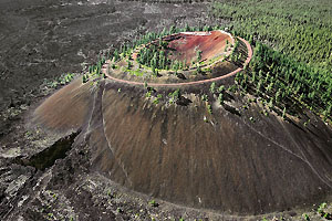 Shuttle—Lava Butte
U.S. Forest Service
58201 U.S. Hwy 97, Bend
541-593-2421
If a long hike in the sun isn't your thing, take the shuttle that runs (approximately) every twenty minutes between the Lava Lands Visitor Center to the top of Lava Butte. A cinder cone, Lava Butte reaches up 500 feet from ground level with a crater 180 feet deep. Take in the spectacular 360-degree view of the surrounding area or walk the unpaved Lava Butte Trail that circles the crater.
{no quote available} —n/a
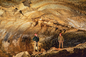 Tours—Lava Caves (Guided)
Wanderlust Tours
61535 S Hwy. 97 Ste. 13, Bend
541-389-8359
Offers one to two hour underground tours in the darkest, quietest spots earth can provide. Learn about the region's geology, the volcanoes that created the caves, cave habitat and the animals it supports, and the natural and cultural history that surround the caves. Please note the caves are "wild" without paved paths or lighting and closed toe shoes are recommended. Includes professional guide, helmet, headlamp, and transportation to and from the cave.
"Wanderlust Tours is the premier destination for cave tours in Bend, Oregon. Our renowned naturalist guides will highlight sweet bits of these cool caverns that might not initially meet the eye." —Wanderlust Tours
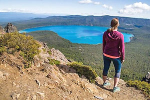 Tours—Newberry Volcanic Monument (Guided)
Wanderlust Tours
61535 S Hwy. 97 Ste. 13, Bend
541-389-8359
Explore the belly of a volcano through a series of hikes inside the Newberry volcano. The tour begins at 6,300 feet and covers fields of pumice and obsidian, the shores of Paulina Lake, and an old-growth Hemlock forest. Comprised of several easy hikes, the tour is just under 2 miles in length. Includes professional guide and transportation to and from the volcano.
"Journey to the top of a volcano, into the depths of an ancient caldera, and over flows of Obsidian." —Wanderlust Tours